.png)
Water Monitoring at the KRLT Headwaters Preserve
- Jan 1, 2025
- 10 min read
Kent Johnson
KRLT Conservation Committee Member
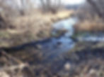
The 48-acre KRLT Headwaters Preserve, near Roberts, Wisconsin, includes the headwaters of the Kinnickinnic River (Kinni). The river emanates from the downstream end of a large wetland (Figure 1), which extends across the preserve from northeast to southwest (Figure 2). This wetland plays a vital role for groundwater infiltration, which maintains the spring flow that fuels the Kinni along its route to the St. Croix River. The wetland also holds, cleans, and filters the overland runoff that enters the preserve, before sending the incoming water downstream. Via these important natural functions and more (see “Wetlands 101” (page 15), from the Wisconsin Wetlands Association), the wetland helps to ensure that the Kinni is cold, clear, and clean as it begins its journey.

Water Monitoring at the KRLT Headwaters Preserve
In April 2024, KRLT initiated a water monitoring project at the KRLT Headwaters Preserve. The monitoring objective is to evaluate the influence of the preserve’s wetland on the Kinnickinnic River, by comparing upstream and downstream temperature and water quality conditions.
Two monitoring stations were established at the upper and lower ends of the preserve, to collect temperature and water quality information. The two station locations (Headwaters Preserve-Upper and Headwaters Preserve-Lower) are shown in Figure 2 below. The Upper monitoring station location is shown in Figure 3, while the Lower station location is pictured in Figure 4.


Temperature Monitoring:
Two Onset TidbiTv2 temperature loggers (Figure 5) were placed in the Kinni, at the Upper and Lower monitoring stations within the preserve. These loggers were programmed to record water temperatures at 10-minute intervals, from April 24-October 22, 2024, resulting in 52,000+ temperature measurements at the two monitoring stations. Marty Engel, Robert Boss, and Kent Johnson were members of the temperature monitoring crew.

Water Quality Monitoring:
Samples for water chemistry analysis will be collected seasonally (summer, fall, winter, and spring) at the upper and lower monitoring stations within the preserve, when the Kinni is flowing normally (baseflow). Baseflow sampling was conducted in July (summer) and October (fall) 2024, and additional baseflow samples will be collected in January (winter) and April (spring) 2025. During April-October 2025, samples will be collected at each station after 2-3 larger rain events, when Kinni flow increases and pollutants are washed from the watershed (runoff events). Water samples are collected using a NASCO Swing Sampler (Figure 6). Steve Leonard, Marty Engel, Robert Boss, and Kent Johnson were members of the water quality monitoring crew in July and October 2024.

All water samples are analyzed by the Metropolitan Council Environmental Services (MCES) Laboratory in St. Paul, MN. Analytes analyzed by the MCES Laboratory include those indicative of the presence of suspended sediment, nutrients, and algae, including:
Suspended Sediment: Total and Volatile Suspended Solids
Suspended sediment is a measure of water clarity, with low concentrations being typical of clear water, and higher concentrations being typical of murky water.
Nutrients: Total and Dissolved Phosphorus
Total and Dissolved Kjeldahl Nitrogen
Nitrate and Nitrite Nitrogen
Ammonia Nitrogen
Like lawn and agricultural fertilizers can create green lawns and crops, elevated levels of nutrients in rivers, lakes, and wetlands can create green waters (Figure 7), due to the presence of excess algae.
Algae: Total and Corrected (Viable) Chlorophyll-a
Chlorophyll-a, a green pigment produced by algae, can be measured to determine the amount of algae present in rivers, lakes, and wetlands.

2024 Monitoring Results:
Temperature Monitoring:
Kinni water temperature measurements at the Upper and Lower preserve monitoring stations in 2024 are displayed as thermographs in Figure 8 below. Monthly mean (average) water temperatures at the Upper and Lower monitoring stations during the May-October period are presented in Figure 9 below.


Of immediate note in the thermographs (Figure 8) at the Upper (blue line) and Lower (green line) monitoring stations is the strong daily (diurnal) temperature pattern. Although cold groundwater continually feeds the Kinni via springs along the entire riverway, the river temperature is greatly influenced by ambient air temperature. During the daylight hours, the river gradually warms and generally reaches a daily maximum temperature in the late afternoon or early evening. At night, the river gradually cools and typically reaches a daily minimum temperature near sunrise. These diurnal temperature fluctuations in the river are natural, and the river’s residents, including trout and macroinvertebrates, have become accustomed to a constantly but slowing changing temperature regime. At the Headwaters Preserve, the diurnal temperature fluctuations at the Upper monitoring station are less pronounced than those at the Lower monitoring station, due to the greater volume of water in the upper wetland, as well as the dense coverage of Common Duckweed (Lemna minor) on the water surface, which provides a shading effect. As the Kinni exits the wetland, the much smaller water volume is more subject to the influence of air temperature, resulting in greater diurnal variation in the river temperature.
Also of note in both thermographs (Figure 8) are the relatively frequent changes in the daily minimum and maximum river temperatures and daily temperature ranges that are influenced by local weather patterns (cold fronts and warm fronts) and seasonal climate changes.
Substantial warming of shallow wetlands can be expected during the summer months (June-August), when air temperatures are warmest, especially with no shading or canopy cover present. This effect was indeed evident at the Headwaters Preserve wetland in 2024. The mean (average) summer (June-August) water temperature at the Upper monitoring station (Figure 8) was 15.6° C, while the mean summer water temperature at the Lower monitoring station was 19.2° C, representing a 3.6° C increase due to the wetland’s warming influence (Figure 8).
While the mean summer temperatures at the Upper and Lower monitoring stations are helpful for evaluating the warming influence of the preserve’s wetland, the percentage of all summer temperatures greater than 20° C at each site (Figure 8) can also be calculated and compared. Scientific research (Armour, 1994) on the preferred temperatures for trout indicates that 20° C is the top of the optimum temperature range for Brown and Brook Trout survival. At the Upper monitoring station, only 0.3% of summer temperatures exceeded 20° C, whereas 29.1% of summer temperatures exceeded 20° C at the Lower monitoring station. Nonetheless, trout and macroinvertebrates can survive in water temperatures exceeding 20° C for short periods of time, and diurnal temperature variation (minimum water temperatures) almost always provided heat relief at the Lower monitoring station, where the Kinni exits the wetland.
During the May-October 2024 period, the monthly mean temperatures at the Upper (blue bar) and Lower (green bar) monitoring stations (Figure 9) also reflect the wetland’s warming influence. In all months except May, the mean temperature at the Lower station was warmer than the mean temperature at the Upper station. The temperature differences between the two stations were greatest in July, August, and September, the three warmest months of 2024. At the Lower monitoring station, mean monthly water temperatures were closely associated with mean monthly air temperatures. At the Upper monitoring station, however, mean monthly water temperatures decreased throughout the May-October period, with some of the lowest temperatures occurring during the warmest months (July-September). This might be due in part to the incremental growth of a dense Common Duckweed mat in the upper wetland (including the Upper monitoring station), which shaded and prevented heating of the underlying water.
Although the wetland at the Headwaters Preserve had a warming influence on the Kinni in 2024, the impact was likely not detrimental to trout and other coldwater inhabitants of the downstream river. With strong groundwater inputs along its route, the Kinni quickly rebounds from any warming influence of the Headwaters Preserve. For example, the mean summer 2024 temperature of the Kinni at Quarry Road, just upstream of River Falls, WI, was 15.1° C, slightly cooler than the mean summer temperature at the Upper preserve monitoring station (15.6° C). Furthermore, no summer temperatures at Quarry Road exceeded 20° C. While the Headwaters Preserve wetland warms the Kinni as it exits the preserve, the wetland also recharges the supply of cold groundwater that contributes to colder downstream river temperatures.
Water Quality Monitoring:
The water samples collected in July and October 2024 at the Headwaters Preserve indicate that water quality in the preserve’s wetland is generally very good during baseflow conditions, when rainfall runoff is not occurring.
Water Clarity:
Soil particles on the landscape are readily carried into rivers, lakes, and wetlands by watershed runoff, reducing water clarity. Water clarity, as indicated via transparency tube measurements, exceeded 100 cm at both preserve monitoring stations during July and October. Accompanying concentrations of total suspended solids (TSS), which can reduce water clarity, were also very low at both monitoring stations, as shown in Figure 10.

Total Phosphorus:
Since phosphorus readily attaches to soil particles (primarily via its usage as a fertilizer), it is often carried into rivers, lakes, and wetlands by watershed runoff. When present in excess amounts, phosphorus is a key nutrient causing the growth of nuisance algae in these waters. For this reason, the Wisconsin Department of Natural Resources (WDNR) has established water quality criteria for total phosphorus (TP) that protect fish and aquatic life from excess algal growth. In the Kinnickinnic River, the total phosphorus criterion that should not be exceeded is 0.075 mg/L. Based on this WDNR criterion, total phosphorus concentrations in the preserve’s wetland (Figure 11) were elevated in July, perhaps reflecting the ongoing influence of June’s heavy rainfall (8.6 inches) and runoff in the Kinni Watershed. Total phosphorus concentrations were substantially lower (and less than the WDNR criterion) in October, perhaps reflecting lower-than-normal rainfall in September (0.8 inch) and October (1.7 inches), with reduced watershed runoff.

Nitrate-Nitrogen:
Nitrate-nitrogen (NO3-N) is commonly used as a fertilizer, to stimulate the growth of agricultural crops and urban/suburban lawns. Since nitrate-nitrogen is soluble in water, any excess not used by plants readily moves through the soil profile and into the underlying groundwater, creating a risk of drinking water contamination. In Wisconsin, about 90% of the nitrate-nitrogen in groundwater comes from the application of nitrogen-containing fertilizers, manure, and biosolids to crop fields. On average, about 20% of applied nitrogen leaches through the soil to groundwater (Wisconsin's Green Fire). Since the Kinni is strongly fed by numerous groundwater seeps and springs along its entire route, elevated nitrate-nitrogen concentrations in groundwater can be transferred to the river, with the potential to impact aquatic life. While WDNR has established a 10 mg/L criterion for nitrate-nitrogen in groundwater, to protect drinking water supplies, no criteria exist for rivers, lakes, and wetlands, making it difficult to determine aquatic life impacts in surface waters. Nitrate-nitrogen concentrations at the two Headwaters Preserve monitoring stations in July and October 2024 are presented in Figure 12.

Nitrate-nitrogen concentrations did not exceed the WDNR drinking water criterion (10 mg/L) at either monitoring station in 2024. At both stations, concentrations were higher in October than in July, perhaps reflecting more groundwater influence within the wetland. During both July and October, nitrate-nitrogen concentrations were noticeably reduced at the Lower monitoring station, compared to the Upper station. A common water quality benefit for a wetland is its ability to reduce nitrate-nitrogen concentrations by denitrification, a biochemical process that converts nitrate-nitrogen in the water to nitrogen gas, which is emitted to the atmosphere. Based on the limited water quality data collected in 2024, it appears that denitrification may be at work in the preserve’s wetland, providing a significant water quality benefit for the Kinni.
Chlorophyll-a:
Green plants (including algae) use chlorophyll (a green pigment) to photosynthesize, a process that employs sunlight to convert carbon dioxide (CO2) and water into glucose, a type of sugar that plants use as food. Chlorophyll a is the predominant type of chlorophyll found in green plants and algae. Chlorophyll a is a measure of the amount of algae growing in a waterbody. Although algae are a natural part of freshwater ecosystems, too much algae can cause aesthetic problems such as green scums and bad odors, and can also result in decreased levels of dissolved oxygen. Blue-green algae (Figures 7 and 13) can produce toxins that may create a public health concern when present in high concentrations. One of the symptoms of degraded water quality is an increase in the amount of algae, as measured by the concentration of chlorophyll a. Waters with high levels of nutrients (especially phosphorus and nitrate-nitrogen) from septic systems, wastewater treatment plants, and agricultural and urban runoff may have excess amounts of algae, hence high concentrations of chlorophyll a (U.S. Environmental Protection Agency).

Chlorophyll a concentrations at the two Headwaters Preserve monitoring stations in July and October 2024 are presented in Figure 14.

Chlorophyll-a concentrations were very low (7.5 ug/L) at both preserve monitoring stations in July, suggesting that very little algae were present. Water clarity indicators, including transparency tube measurements and TSS concentrations (Figure 10), also confirm the lack of algal presence during the peak of summer. In October, chlorophyll-a concentrations were higher at both monitoring stations, with the highest concentration (38 ug/L) at the Upper station. These higher chlorophyll-a concentrations likely reflect the extensive development, by October, of a duckweed mat on portions of the wetland’s water surface, particularly at the Upper monitoring station, where duckweed coverage of the water surface was 100%. Nonetheless, water clarity at both monitoring stations (Figure 10) remained excellent in October. The lack of algae and excellent water clarity in July and October suggest that the preserve wetland is healthy and creating water quality benefits for the Kinni.
Water quality monitoring is still underway at the Headwaters Preserve. In 2025, seasonal baseflow samples will be collected in January and April, and 2-3 samples will be collected during runoff events in the April-October period. The availability of all 2024-2025 water quality data will better allow an analysis of the ability of the Headwater Preserve’s wetland to improve water quality in the Kinni by reducing suspended sediment, nutrients, and the presence of nuisance algae.
Benefits of Water Monitoring at the KRLT Headwaters Preserve:
KRLT and partners have made a significant investment to establish the Headwaters Preserve, thereby providing permanent protection for the headwaters of the Kinnickinnic River, an Outstanding Resource Water and Class 1 trout stream in Wisconsin, as well as a nationally known water resource. The water monitoring project at the preserve will enable KRLT and public users to better understand the water quality benefits provided by protecting this very special place. KRLT has recently embarked on a major project to restore the preserve uplands to prairie and oak savanna. Collection of current, baseline water quality information in 2024-2025 will also allow KRLT to evaluate the future benefits of upland restoration for protecting and/or improving the preserve’s water features, including the Kinni as it begins its 25-mile journey to the St. Croix River.
Data collected by KRLT Conservation Committee Members:
Robert Boss, Marty Engel (KRLT Staff Member), Kent Johnson, and Steve Leonard (KRLT Staff Member).